Central Indiana Weather Update | June 15, 2025
This Article Includes
- 1 Central Indiana Weather Update | June 15, 2025
- 1.1 Tonight:
- 1.2 Monday:
- 1.3 Related posts
- 1.4 ‘Colossal waste of time’: Retired general slams Trump’s Army Day parade
- 1.5 Texas lawmakers clash over protests, National Guard deployment, and Trump’s immigration policies
- 1.6 Monday Night:
- 1.7 Tuesday:
- 1.8 Tuesday Night:
- 1.9 Wednesday:
- 1.10 Wednesday Night:
- 1.11 Thursday (Juneteenth):
- 1.12 Thursday Night:
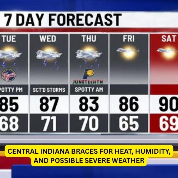
- 2 7-Day Outlook:
Tonight:
Skies stay mostly cloudy with light northeast breezes between 5–10 mph. Most areas remain dry, but the air will feel warm and a bit muggy. Overnight lows dip to around 66°F.
Monday:
Expect a mix of sun and clouds with highs near 85°F. Spotty afternoon showers and storms could pop up between 2–5 PM. Any storms that form might bring brief, heavy rain. Winds stay light and variable, slightly from the east.


Monday Night:
A few isolated storms may linger after 8 PM, but most areas will be calm under mostly cloudy skies. It stays mild, with lows near 68°F and light southeast breezes.
Tuesday:
The chance for storms picks up. A few morning showers are possible, followed by scattered thunderstorms after 11 AM. Heavier downpours could occur, mainly west of Indianapolis. Highs reach around 88°F, with southwest winds at 5–10 mph.
Tuesday Night:
Scattered storms continue overnight. Skies remain partly to mostly cloudy with warm, humid air and lows around 71°F. Winds hold steady from the south-southwest at 5–10 mph.
Wednesday:
Storms become widespread as a stronger system moves in. Expect showers and thunderstorms throughout the day, especially after 2 PM. Some storms may be strong or severe. Highs in the mid 80s, with west-southwest winds at 10–15 mph and gusts up to 20 mph. Rain chance: 80%.
Wednesday Night:
Heavy rain and storms continue through the night, especially before 2 AM. Storms may linger into early morning. Lows around 69°F with gusty southwest winds. Rain chance: 80%.
Thursday (Juneteenth):
As the front shifts east, a few storms may linger in the afternoon east of I-65. Otherwise, expect partly sunny skies and a high near 83°F with west winds at 10 mph. Rain chance: 30%.
Thursday Night:
Remaining showers taper off before midnight. Mostly clear and slightly cooler, with a low near 64°F and calm winds.
7-Day Outlook:
A warm and stormy stretch continues early this week. Monday brings a slim storm chance, while Tuesday and Wednesday see a rise in rain and storm activity, with possible severe weather midweek. Juneteenth may begin wet but should dry out by afternoon. By Friday, sunshine returns with highs in the upper 80s. The weekend turns hotter, with sunny skies and low 90s both Saturday and Sunday. Heat indices may top 100°F by Sunday afternoon.


