Hurricane Erick, the second named hurricane of the Pacific season, has officially formed and is already impacting parts of southern Mexico—with potential indirect effects reaching Southern California.
Current Status of Hurricane Erick
This Article Includes
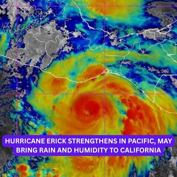
As of Wednesday morning, Hurricane Erick was located about 160 miles south-southeast of Puerto Angel, Mexico, with maximum sustained winds of 75 mph and higher gusts.


The National Hurricane Center (NHC) warned that the storm is undergoing “rapid strengthening” and could reach Category 3 status by Thursday, with wind speeds possibly exceeding 111 mph.
The center of Erick is expected to approach or move inland near the southern coast of Mexico late Wednesday into Thursday.
Impact on Mexico
Forecasters are warning of life-threatening flash floods and mudslides across southern Mexico, particularly in the states of Oaxaca and Guerrero, where rainfall totals could reach up to 20 inches in some areas. Additional rainfall between 3 to 8 inches is forecast across Chiapas, Michoacan, Colima, and Jalisco.
Swells from the storm are also expected to produce dangerous surf and rip currents, adding to the risks for coastal communities.
Warnings in effect:
-
Hurricane Warning: Acapulco to Puerto Angel
-
Hurricane Watch: West of Acapulco to Tecpan de Galeana, east of Puerto Angel to Bahias de Huatulco
-
Tropical Storm Warning: East of Puerto Angel to Salina Cruz
Potential Effects on California
Although Hurricane Erick is not expected to make landfall in California, it may still affect the region by:
-
Increasing humidity levels
-
Bringing inland thunderstorms, especially in mountainous areas
-
Generating high surf and rip currents along Southern California beaches
These indirect impacts are common with Eastern Pacific hurricanes, even when they remain well offshore.
Hurricane Formation Basics
Hurricanes form over warm tropical waters (above 80°F) where clusters of thunderstorms can evolve into rotating systems.
-
At 39 mph, they become tropical storms.
-
At 74 mph, they’re officially classified as hurricanes.
Forecast Tools
The “cone of uncertainty” used in forecast track maps outlines the most likely path of the storm’s center, but the storm can move outside this path about 33% of the time.
Spaghetti models, which show a range of potential tracks, help forecasters visualize the uncertainty and variation in model predictions.
As Hurricane Erick strengthens, both Mexico and Southern California are on alert for its impacts. Stay tuned to updates from the National Hurricane Center and local authorities for the latest developments.


